| |
 |
 |
 |
 |
 |
 |
 |
 |
 |
 |
 |
 |
 |
 |
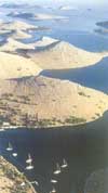 KORNATI KORNATI
In the central part of croatian Adriatic
Sea, about 15 Nm to the west from Šibenik
town, 7 Nm to the southwest from Murter,
or 15 Nm to the south from Zadar town, there
is amazing group of islands named Kornati
archipelago.
Beauty and singularity of the archipelago
moved authorities in 1980 to proclaim a
bigger part of that area national park.
Since then certain modifications of its
borders were made, so that nowadays Kornati
National Park occupies the area of about
220 km2
(54.000 acres). There are 89 islands, islets
and reefs within the area of Kornati National
Park (185 km of the coastline), what makes
it the most indented group of islands in
the Mediterranean.
The land part of Kornati National
Park covers less than 1/4 of its
total area, but the values of its landscapes,
the "crowns" (cliffs) on the islands
facing the open sea, and interesting relief
structures, make this part of Kornati National
Park unique. Besides, the Kornati submarine
area, whose biocenosis are considered to
be the richest in the Adriatic Sea, and
also the magnificent geomorphology of the
sea bed attracts divers from all over Europe
to come and enjoy in unforgettable submarine
adventures.
For more information visit:
www.tel.hr/np-kornati |
|
 |
|
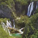
 KRKA KRKA
It was proclaimed a national park in 1985.
and is the seventh national park in Croatia.
The Krka National Park
is located entirely within the territory
of Šibnik-Knin County and encompasses an
area of 109 square kilometers along the
Krka River: two kilometers downriver from
Knin to Skradin and the lower part of the
Čikola River.
From the flooded part of the mouth, it is
72.5 kilometers in length, making the Krka
the 22nd longest river in Croatia. The source
of the Krka River is at the base of the
Dinaric Mountains, 3.5 kilometers northeast
of the base of Knin and 22 meters below
Topoljski Slap, Veliki Buk and Krčić Slap,
which are noisy cascades in the winter but
run dry during the summer.
The length of the freshwater section of
the river is 49 kilometers and that of the
brackish section is 23.5 kilometers. Significant
tributaries of the Krka River include Krčić,
Kosovčica, Orašnica, Butišnica and Čikola
with Vrb. With its seven travertine waterfalls
and a total drop of 242 meters, the Krka
River is a natural and karstic phenomenon.
For more information visit: www.npkrka.hr
|
|
|
|
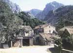 PAKLENICA PAKLENICA
With its surface area of 96 km2,
from the eastern coast of the Adriatic Sea
to the highest peaks of the Velebit Mountains,
Vaganski Vrh (1757 m) and Sveto Brdo (1753
m), Paklenica abounds with numerous natural
wonders and phenomena, which is why the
entire area was proclaimed a national park
in 1949. And rightfully so, as this region
is simple and unusual in its connection
between the sea and the mountains, rich
in beech and black pine forests, its deep
canyons cut vertically into the Velebit
ridge, its karst formations and numerous
caves and pits.
For more information visit: www.tel.hr/paklenica |
|
|
|
 PLITVIČKA
JEZERA PLITVIČKA
JEZERA
The natural attributes of the Plitvice
Lakes National Park, uniqueness
and sensibiliry of that phenomenon, deserve
a full attention of our visitors.
Recreational aspect of stay and the amazement
with beauty of the area that conquers by
its natural diversity and harmony of shapes
and colours in any of the seasons, is based
on many mutually conditioned natural characteristics.
For more information visit: www.np-plitvicka-jezera.hr |
|
|
|
|
|
|
 |
|
|